Now Reading: Lençóis Maranhenses National Park: A Landscape of Contradiction
-
01
Lençóis Maranhenses National Park: A Landscape of Contradiction
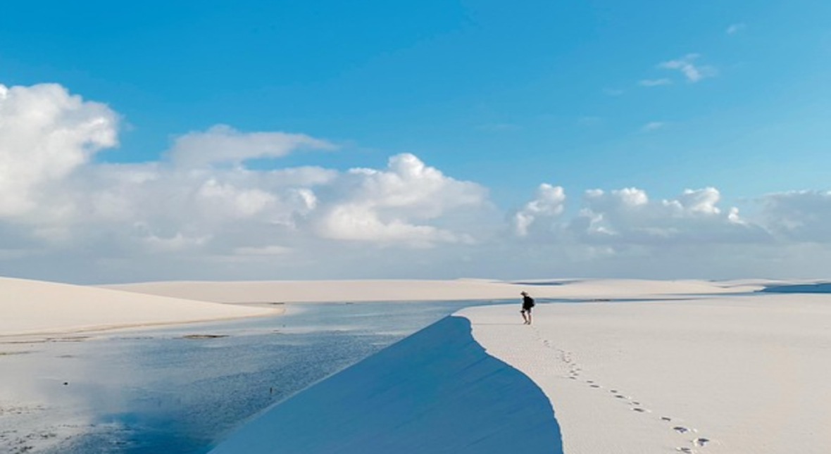
Lençóis Maranhenses National Park, located in the northeastern Brazilian state of Maranhão, presents one of the most scientifically fascinating paradoxes in nature. At first glance, it looks like a vast desert: undulating white sand dunes stretch endlessly in all directions, evoking images of the Sahara. Yet, unlike true deserts, this region receives over 1,200 to 1,600 mm of rainfall annually—more than cities like London or Rome. The heavy seasonal rains, combined with its unique topography and geology, allow thousands of freshwater lagoons to form between the dunes, making Lençóis Maranhenses a rare and dynamic ecosystem where water and sand interact in surprising ways. The name “Lençóis,” which means bedsheets in Portuguese, aptly captures the appearance of the rippling dunes.
Geological Origins of the White Dunes
The shimmering white dunes that dominate the landscape are composed of almost pure quartz sand—one of the most chemically stable and erosion-resistant materials on Earth. These sands are believed to have originated from eroded continental rocks in the Brazilian interior and were transported to the Atlantic Ocean via rivers like the Parnaíba and Preguiças. From there, coastal currents and wind patterns gradually moved the sediments back inland. Over tens of thousands of years, prevailing northeast trade winds have sculpted these sands into crescent-shaped dunes—called barchans—which can reach heights exceeding 40 meters. Their fine particle size, low mineral contamination, and high reflectivity account for the park’s dazzling brightness, which can be almost blinding under midday sun.
A Desert in Appearance Only
Despite its desert-like scenery, Lençóis Maranhenses is not classified as a desert because it does not meet the strict climatic criteria. True deserts receive less than 250 mm of rainfall annually, but Lençóis Maranhenses receives five to six times that amount, mainly between January and June. The region’s climate is categorized as tropical monsoon, and its precipitation is driven by the Intertropical Convergence Zone (ITCZ)—a belt of low pressure encircling the Earth near the equator, where trade winds from both hemispheres converge and cause intense rainfall. This abundance of rain over a landscape with poor drainage characteristics gives rise to the park’s most iconic feature: ephemeral freshwater lagoons.
How Lagoons Form and Disappear
The lagoons appear when seasonal rains fill the troughs between dunes. Beneath the sands lies a crucial feature: an impermeable layer of clay and rock, which prevents the rainwater from draining away quickly. As a result, the rainwater pools in the valleys, forming thousands of individual lagoons with variable size, shape, and depth. During the peak of the rainy season, typically around May to August, these lagoons can reach depths of up to 3 meters and extend hundreds of meters in length. By contrast, during the dry season (September to December), high temperatures and solar radiation cause rapid evaporation, shrinking the lagoons dramatically or eliminating them altogether by late October.
The Hydrological Engine
The entire system functions like a natural clock, driven by rainfall and solar energy. Hydrologists have studied the region to understand its water retention dynamics, noting that the capillary action within the fine-grained sand helps retain water near the surface, even during dry spells. Additionally, the sand’s low porosity and the hardpan beneath contribute to the persistence of surface water. Interestingly, some larger lagoons maintain partial volumes year-round, sustained by localized aquifers and subterranean seepage, though most are purely seasonal. The variability of rainfall from year to year means lagoon size and longevity are never exactly the same, making each season a unique hydrological event.
Life in a Temporary World
Surprisingly, the short-lived lagoons support diverse and adaptive life forms. Microorganisms, algae, plankton, and even small fish flourish in these freshwater oases. One of the most fascinating species is the wolf fish (Hoplias malabaricus), which survives the dry season through a process called aestivation—a dormant state in which it buries itself in wet sand and significantly reduces its metabolic rate. When the rains return, the fish rehydrate and become active within hours. Other temporary aquatic species, such as microcrustaceans, tadpoles, and insect larvae, synchronize their life cycles with the hydrological rhythm, completing their development within weeks. This pulse of productivity has ripple effects across the food chain.
Vegetation Patterns and Dune Edges
While the interior dune fields are largely barren, plant life flourishes at the edges and in transitional zones. Here, ecosystems such as restinga (coastal shrubland) and várzea (seasonally flooded forest) emerge. Plants in these zones have adapted to conditions of high salinity, shifting substrates, and intense sunlight. Common species include cacti, bromeliads, crotons, and tough grasses. These plants play a critical role in dune stabilization, trapping wind-blown sand and providing habitat for insects, small reptiles, and birds. Over time, they create micro-environments that encourage further colonization and ecological succession, leading to greater biodiversity along the park’s margins.
The Role of Mangroves and Coastal Wetlands
To the north and northeast, where the dunes meet the Atlantic coast, lie extensive mangrove forests and estuarine systems, particularly along the Preguiças River delta. These environments are highly productive and support large populations of fish, crabs, mollusks, and wading birds. Mangrove species such as Rhizophora mangle, Avicennia germinans, and Laguncularia racemosa dominate these coastal fringes. They stabilize sediment, buffer storm surges, and serve as critical nurseries for marine species. The mingling of freshwater and saltwater in these tidal zones creates complex biogeochemical conditions, which scientists study to better understand nutrient cycling and carbon sequestration.
Migratory Birds and Ecological Corridors
Each year, Lençóis Maranhenses becomes a temporary haven for tens of thousands of migratory birds. The park sits along a vital migratory flyway connecting North and South America. Birds such as the scarlet ibis, white egret, semipalmated sandpiper, and black-bellied plover use the lagoons as stopover sites to rest and refuel. The rich supply of insects, crustaceans, and small fish makes this an ideal feeding ground during their long journeys. Bird biologists frequently conduct fieldwork in the region, banding and tracking these avian travelers to study migration routes, timing, and climate-linked changes in behavior.
Aeolian Processes and Dune Migration
The dunes are not static; they are in constant motion, shaped by the relentless force of coastal winds, which average 20 to 30 km/h. As a result, dunes can migrate 10 to 20 meters per year, slowly altering the landscape. This movement causes some lagoons to be buried while new ones form elsewhere. Scientists use remote sensing technologies—such as satellite imagery, drones, and LIDAR scanning—to map dune migration and understand patterns of sand transport. These data help researchers model how the landscape might respond to climate change, rising sea levels, or land use changes in surrounding regions.
Threats, Climate Change, and Conservation
Although the park is protected under Brazilian law as a national park since 1981, Lençóis Maranhenses faces several environmental challenges. Climate change poses the most serious long-term threat. A projected increase in average temperatures and shifts in rainfall patterns could shorten the lagoon season or disrupt the ecosystem’s natural rhythms. Human activity also impacts the area: unregulated tourism, off-road driving, and illegal fishing can damage dune structures, stress wildlife, and pollute lagoons. Conservationists are working with ICMBio (Chico Mendes Institute) to implement education campaigns, promote eco-tourism, and enforce stricter access rules to protect this fragile ecosystem.
A Rare Intersection of Earth Systems
Lençóis Maranhenses is more than a photogenic wonder—it is a living laboratory for studying the interaction between climate, geology, hydrology, and biology. Its seasonal transformations offer unique insights into how ecosystems adapt to extreme variability and temporary abundance. For scientists, it provides a model for studying resilience in ecosystems, species adaptation, and the hydrology of sandy environments. For visitors, it offers an awe-inspiring reminder that nature’s most beautiful spectacles often arise from the unlikely meeting of opposing forces: sand and water, drought and abundance, movement and permanence.


Related Posts

Stay Informed With the Latest & Most Important News
Previous Post
Next Post


Advertisement